


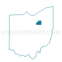
WESTFIELD TWP A Voting District, Medina County, Ohio
About
Outline

Summary
| Unique Area Identifier | 649930 |
| Name | WESTFIELD TWP A Voting District |
| County | Medina County |
| State | Ohio |
| Area (square miles) | 11.89 |
| Land Area (square miles) | 11.88 |
| Water Area (square miles) | 0.01 |
| % of Land Area | 99.95 |
| % of Water Area | 0.05 |
| Latitude of the Internal Point | 41.00527120 |
| Longtitude of the Internal Point | -81.92356690 |
Maps


Graphs
Select a template below for downloading or customizing gragh for WESTFIELD TWP A Voting District, Medina County, Ohio


Neighbors
Neighoring Voting District (by Name) Neighboring Voting District on the Map
- Voting District CANAAN TWP 2 BURBANK, Wayne County, OH
- Voting District CANAAN TWP 4, Wayne County, OH
- Voting District CANAAN TWP 5 CRESTON, Wayne County, OH
- GUILFORD TWP A Voting District, Medina County, OH
- HARRISVILLE TWP A Voting District, Medina County, OH
- HARRISVILLE TWP B Voting District, Medina County, OH
- Voting District MILTON TWP 2, Wayne County, OH
- SEVILLE VIL A Voting District, Medina County, OH
- SEVILLE VIL B Voting District, Medina County, OH
- WESTFIELD CENTER VIL Voting District, Medina County, OH
- WESTFIELD TWP B Voting District, Medina County, OH
Top 10 Neighboring County Subdivision (by Population) Neighboring County Subdivision on the Map
- Milton township, Wayne County, OH (9,376)
- Canaan township, Wayne County, OH (4,875)
- Guilford township, Medina County, OH (3,203)
- Westfield township, Medina County, OH (2,482)
- Seville Village township, Medina County, OH (2,296)
- Harrisville township, Medina County, OH (1,836)
- Westfield Center village, Medina County, OH (1,115)
- Creston Village township, Medina County, OH (92)
Top 10 Neighboring Place (by Population) Neighboring Place on the Map
Top 10 Neighboring Unified School District (by Population) Neighboring Unified School District on the Map
Top 10 Neighboring State Legislative District Lower Chamber (by Population) Neighboring State Legislative District Lower Chamber on the Map
Top 10 Neighboring State Legislative District Upper Chamber (by Population) Neighboring State Legislative District Upper Chamber on the Map
Top 10 Neighboring 111th Congressional District (by Population) Neighboring 111th Congressional District on the Map
Top 10 Neighboring Census Tract (by Population) Neighboring Census Tract on the Map
- Census Tract 4130, Medina County, OH (5,614)
- Census Tract 4120, Medina County, OH (4,114)
- Census Tract 24, Wayne County, OH (3,940)
- Census Tract 23, Wayne County, OH (2,966)
- Census Tract 25, Wayne County, OH (2,539)
- Census Tract 4110.01, Medina County, OH (1,718)